Mariner 9 UVS data on Google Mars
Description
Mariner 9 UVS reflectance data are displayed on Google Mars. The Mariner 9 observations were made between January 19, 1972 and February 29, 1972. The spacecraft was in a 12 hour orbit designed to map the entire planet. Even-numbered orbits which had the higher data rate were used in this analysis. The Mariner spectra between 2107 and 3497 A were calibrated and then divided by the solar irradiance to produce the reflectance which is displayed here. The solar irradiance data was taken from the SORCE mission which made the observations during September 1994 two solar cycles later. On Google Mars the footprint of each observation is displayed as a colored rectangle with color indicating the reflectance intensity at 3049 A. The intensity at this wavelength is influenced by pressure of the atmosphere, the amount of dust in the atmosphere, the presence of ice crystals, and the ground albedo. Blue means a large intensity, red a low intensity. The ultraviolet reflectance is displayed in a balloon associated with each footprint. By clicking on a footprint, a large balloon appears with the reflectance intensity between 2100 and 3500 A and ancillary information about the observation such as the time, latitude and longitude, mu, the cosine of the viewing angle and mu0, the cosine of the solar zenith angle, the orbit number, the DAS time, and the intensity at 3049 A. The DAS time comes from the spacecraft clock and is in arbitrary units.
UVS data from thirteen orbits are included in this data set. They include observations of ozone on Mars, the reflectance on top of Olympus Mons the highest point on Mars, scans across Valles Marineris the large rift valley, and observations made at the same location 37 days apart showing varying amounts of dust in the atmosphere.
First Time/Installing Google Mars
- Download and install Google Earth
- Launch Google Earth
- Turn on Google Mars (Menu layer>Explore>Mars)
- Select “Hide Google Earth” or minimize the application
- Download this file: http://lasp.colorado.edu/pdr/mariner9/GoogleMars/MM71.kml Open manually if it does not automatically load in Google Mars
- The file will be displayed in the Temporary section of the left sidebar as MM71
- Using File on the menu, save to My Places (or drag it to the Bookmarks section)
Using The Mariner 9 Reflectance Layer
The Google Mars display will reappear and there will be a new entry labeled MM71 in places in the sidebar on the left hand side of the display.
- Click on the arrow next to MM71.
- Click on the arrow next to MM71 Orbits.
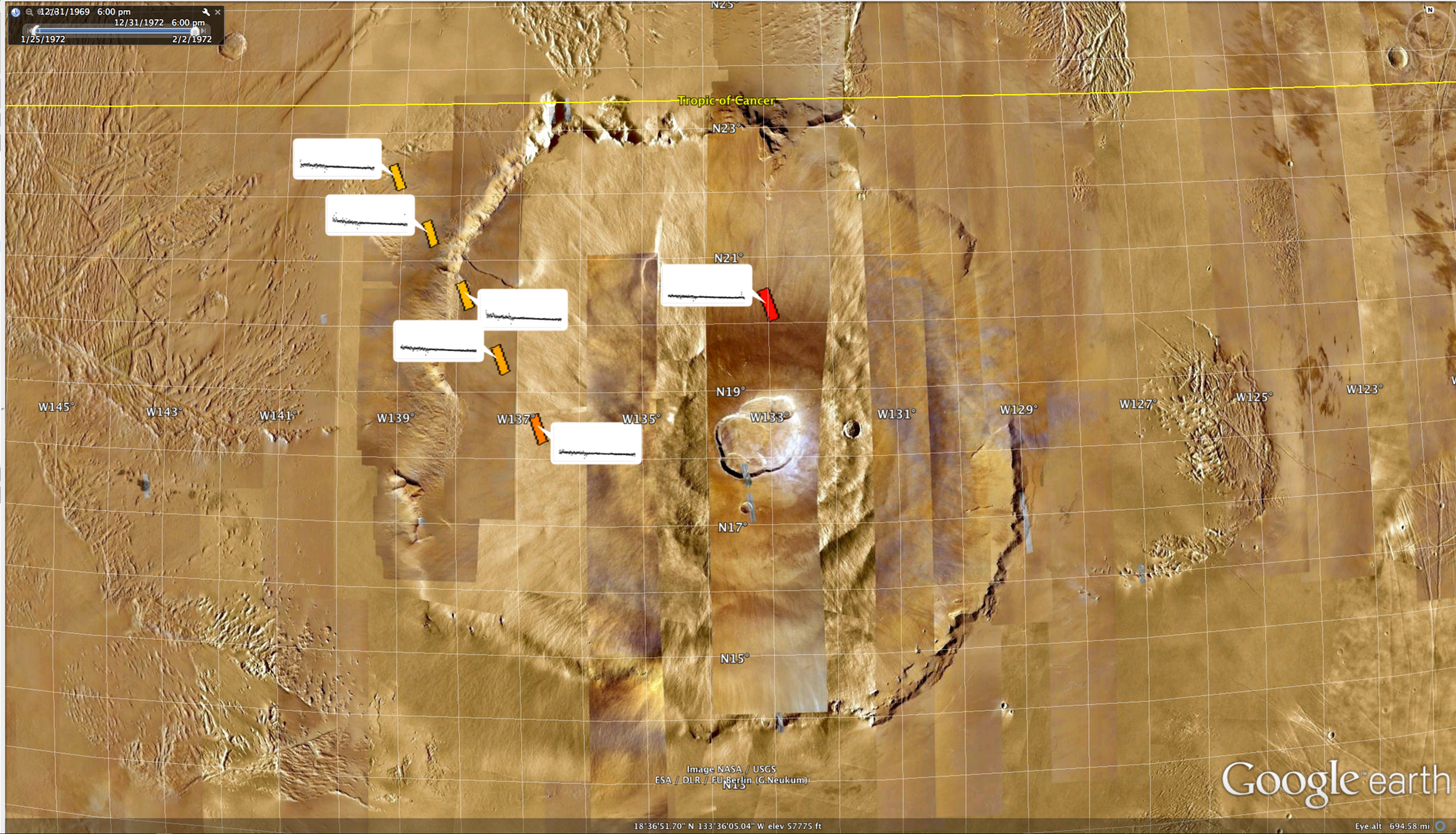
- Double-click on Initial View. Olympus Mons should be displayed on the Mars globe.
- Zoom out to view all of Olympus Mons.
- Zoom in to observe footprints at the top and along the NNW slope of Olympus Mons. Six footprints should be displayed, one red, the rest orange or yellow-orange. Zoom in further to observe the small balloons that show the reflectance data at these locations.
- Click on the Red footprint on the top to display the 3049A refelectance (0.008) at one of the highest places on Mars.
- click on the yellow-orange footprint at the base of Olympus Mons to display the reflectance 15km lower. (0.013)
The reflectance intensity at these two locations shows the contribution of 15km of atmosphere to the reflectance. The reflectance intensity at the location of the red footprint is mostly from the ground albedo. At the location of the yellow-orange footprint, the reflectance intensity is the sum of the ground albedo and atmospheric scattering. Orbit 146 & 148 show the complete data tracks across Olympus Mons.
Exploration
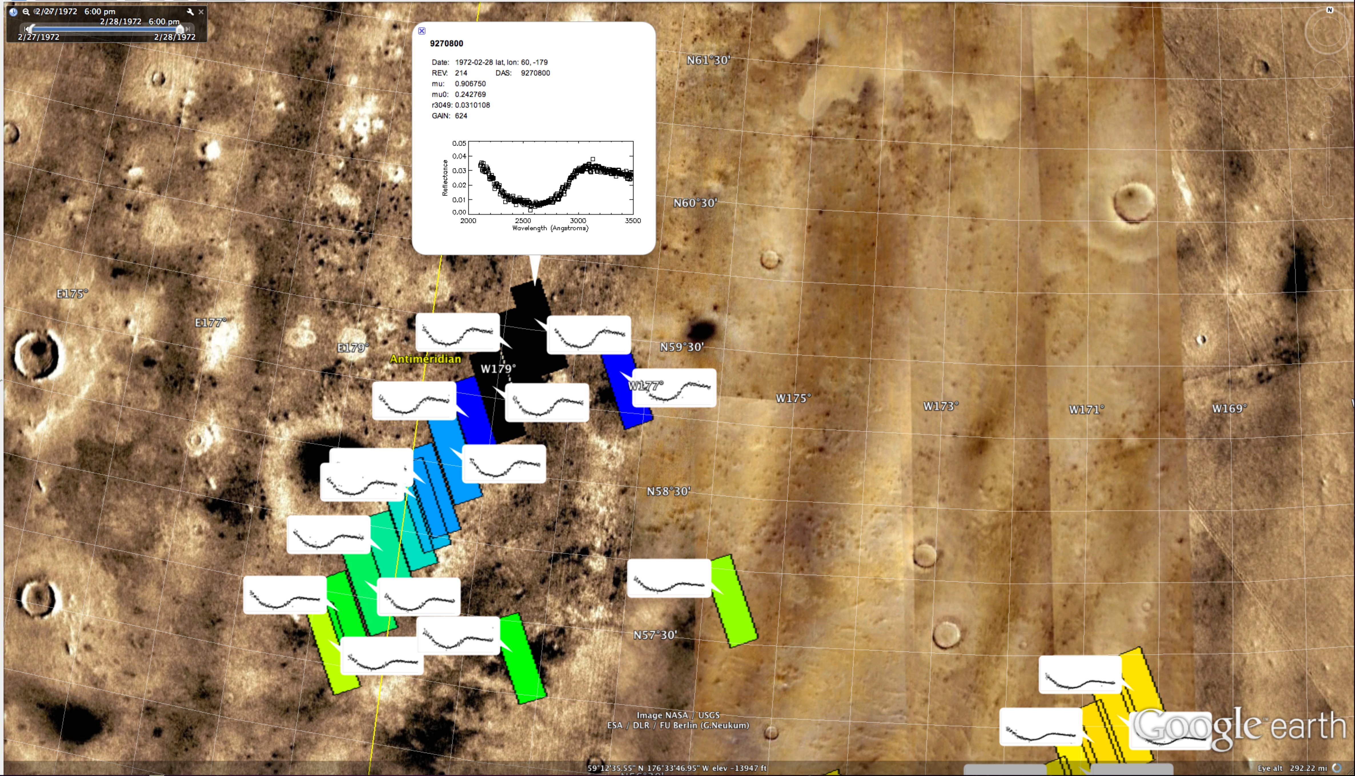
Click on one of the numbered orbits; for example Orbit 214. The following entries will appear; Footprints, Quick Look, and Non-mapping Orbits. Click on the arrow next to Non-mapping Orbits and the entries Footprints and QuickLook will appear. Initially, only Footprints should be on. At the upper left hand side of the Google display, there is a time bar. Click on the Toggle icon to display footprints on the Mars globe. Using the Google controls on the upper right hand side of the display, rotate the Mars globe until you locate the track of the footprints. If the footprint tracks do not appear, move the markers along the time slider. Zoom in on the footprints until the color appears and the footprint size is satisfactory for viewing. Using the Google controls, move along the tracks. Click on the footprints to display the large balloons with ancillary data. To display the reflectance associated with each footprint, go to places on the left hand side of the Google window and click on QuickLook. Zoom in to have the multi-balloons appear. Using the Google controls, move along the track to see how the reflectance changes.
Orbits 212 and 216 also show the appearance of ozone at high latitudes. Start at low latitudes and move northward. Ozone will appear north of 50° N. (See the abstract in this Ozone on Mars publication.)
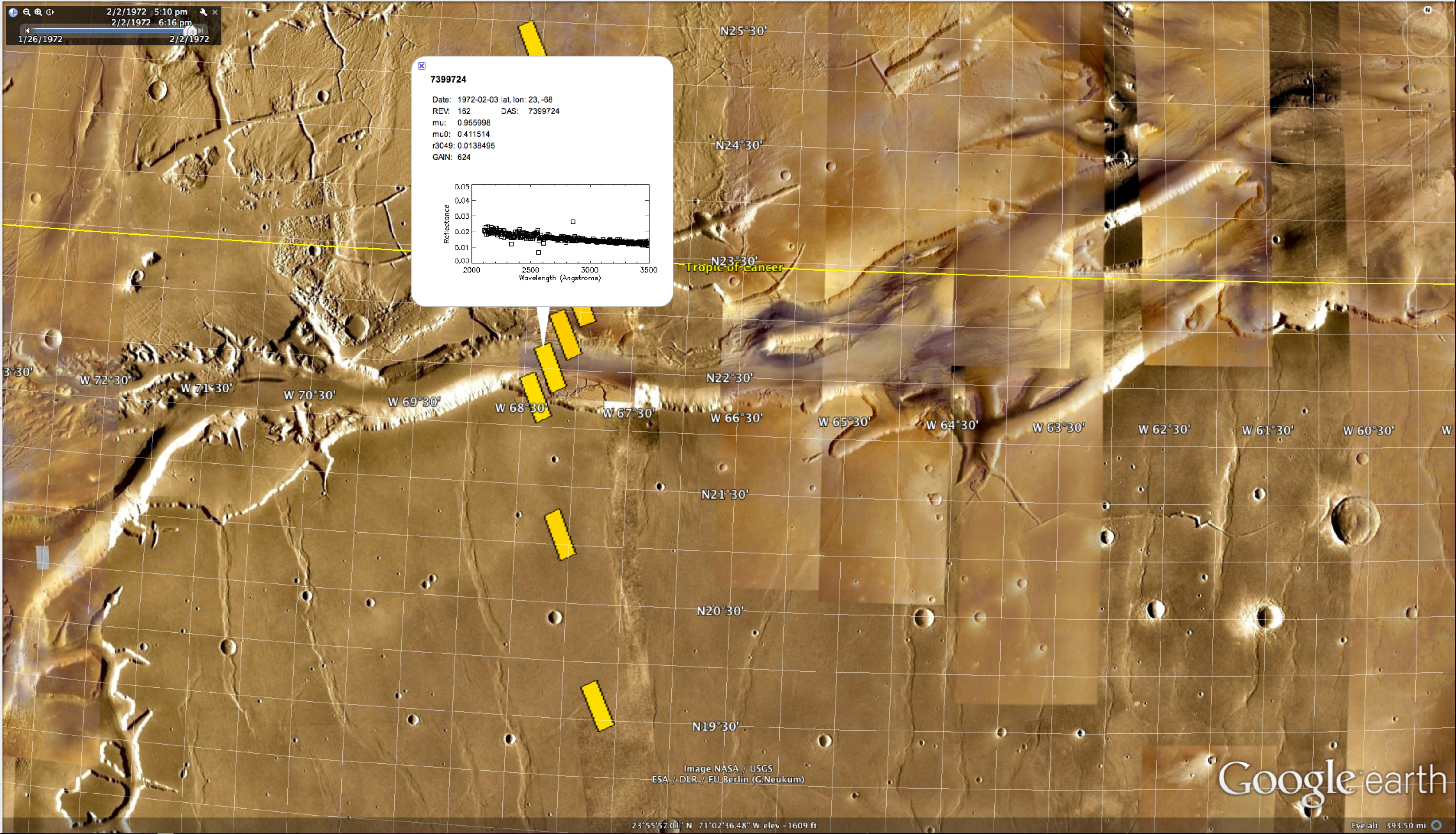
Orbits 162, 164, 166, and 168 cross Valles Marineris. The depth of this rift valley is 8 km lower than the adjacent plateau. Compare the reflectance between the valley and the plateau.
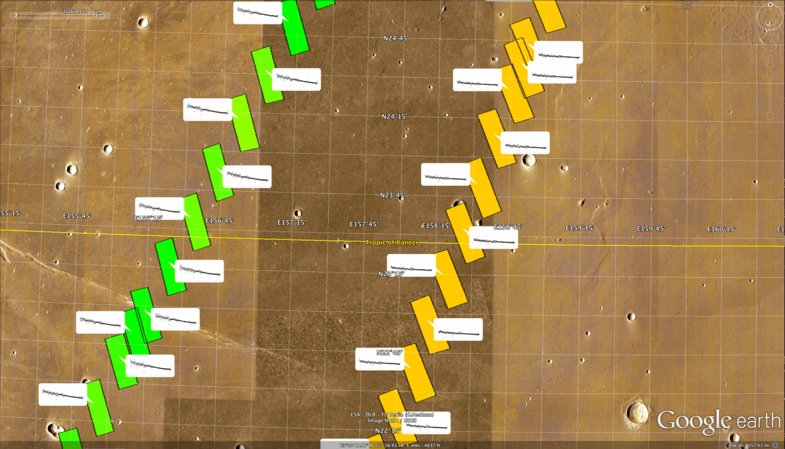
Orbits 134 and 210 show the same locations 37 days apart. In the earlier orbits, there is still considerable dust in the atmosphere. In the later orbits, most of the dust has settled out. To properly compare these reflectance data, a radiative transfer model should used because although the viewing angles are nearly the same, the solar zenith angles are different for the early and late orbits.
The Mariner 9 UVS publications may be found on the following page:
https://lasp.colorado.edu/mariner9/publications
The DAS time comes from the spacecraft clock and is in arbitrary units.
( See https://lasp.colorado.edu/mariner9/UVSdata/ for more detail about the UVS data.)
The kdm-idl Mars layer was developed for Google Earth by Ken Mankoff (https://code.google.com/p/kdm-idl).
For Troubleshooting and Frequently Asked Questions:
https://lasp.colorado.edu/mariner9/google-mars/faq/
For access to the complete set of 57 orbits, click here.