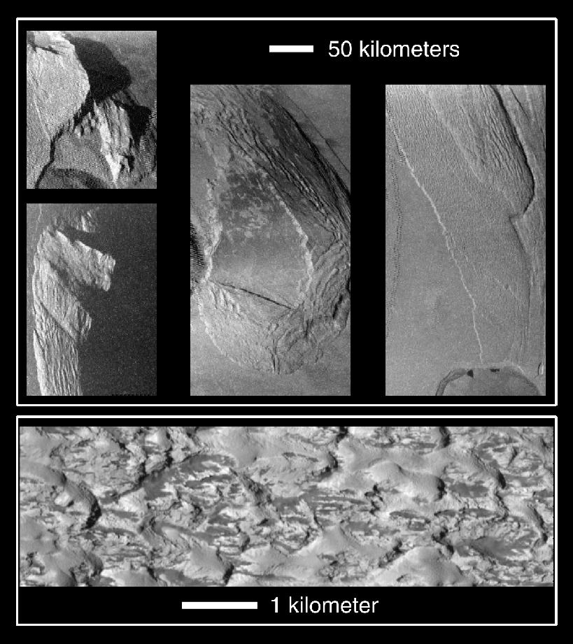
Unusual mountains on Jupiter's moon Io are shown in these images that were captured by NASA's Galileo spacecraft during its close Io flyby on October 10, 1999. The top four pictures show four different mountains at resolutions of about 500 meters (1,600 feet) per picture element. The bottom picture is a closeup of another mountain. It is also one of the highest resolution images ever obtained of Io, with a resolution of 9 meters (30 feet) per picture element. The lower resolution images show a range of mountain structures from angular peaks on the left to gentler plateaus, surrounded by very gently sloping debris aprons on the right.
Galileo scientists believe that these images illustrate the deterioration of Ionian mountains. If this is the case, it means that the more angular mountains on the left are younger than the rounded mountains on the right. Almost all of the mountains exhibit ridges parallel to their margins. These ridges indicate material is moving down the sides of the mountains due to gravity. The ridges are similar to structures observed at the base of Olympus Mons on Mars, so comparative studies may help us understand surface processes on both planets. The very high-resolution image shows a closeup of a degraded mountain. This image (which is strikingly different from the other image of comparable resolution which targeted recent lava flows) shows a lumpy landscape. Curiously, the variation in brightness between the dark and light areas within this image is the greatest seen to date on Io. Galileo scientists are continuing to investigate the processes that produce this puzzling surface.
The Sun illuminates the surface from the left in all five images. North is to the top in the top four images. In order to keep the Sun angle consistent in all of the images, north is to the bottom in the bottom image. The upper left image is centered at 18.7 degrees north latitude, 81.4 degrees west longitude, and covers a region 175 kilometers (108 miles) by 170 kilometers (106 miles). The lower left image is centered at about one degree north latitude and 81.7 degrees west longitude and covers a region 135 kilometers (84 miles) by 200 kilometers (124 miles). The middle image is centered at 25.6 degrees north latitude, 96.7 degrees west longitude and covers a region 130 kilometers (81 miles) by 275 kilometers (170 miles). The right image is centered at 14.4 degrees north latitude, 104.7 degrees west longitude and covers a region 125 kilometers (78 miles) by 205 kilometers (130 miles). The bottom image is centered at 4 degrees north latitude and 214.6 degrees west longitude and was taken at a range of 882 kilometers (548 miles).
Image produced by: Zibi Turtle and Alfred McEwen, Planetary Image Research Lab. (PIRL), Lunar and Planetary Lab. (LPL), University of Arizona
The Jet Propulsion Laboratory, Pasadena, CA manages the Galileo mission for NASA's Office of Space Science, Washington, DC. JPL is a division of the California Institute of Technology, Pasadena, CA.
This image and other images and data received from Galileo are posted on the World Wide Web, on the Galileo mission home page at http://galileo.jpl.nasa.gov/. Background information and educational context for the images can be found at http://galileo.jpl.nasa.gov/images/io/ioimages.html.
NASA's Planetary Photojournal PIA-02513
November 19, 1999