Supplemental Material:
Table of SSI observations (.pdf)
Table of NIMS observations (.pdf) (.doc)
Galileo SSI Footprint Map (.jpg) (SMALL .jpg)
 PIA00496.jpg
Original Caption Released with Image:
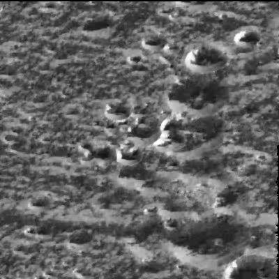
Scientists believe that water-ice frosts are the likely cause for the brightening seen around the circular rims of these craters located at a high northern latitude (57 degrees) on Jupiter's moon Ganymede in this image taken by NASA's Galileo spacecraft on September 6, 1996. The image, just recently radioed to Earth from the spacecraft, shows the same kind of bright, high-latitude surface areas as those first seen by the Voyager spacecraft in 1979, but at higher resolution (this image spans about 18 kilometers or 11 miles on a side). Even though the Sun is shining from the south, the north-facing walls of the ridges and craters are brighter than the walls facing the Sun. This is interpreted to mean that the very bright north-facing slopes are covered with surface water-ice frosts, and that these frosts preferentially accumulate in such high-latitude locations. Galileo scientists say that at the high resolution seen in Galileo images, the high-latitude brightness seen by Voyager is partly attributable to frosts forming on cooler, north-facing slopes.
The right-hand side of the image is dominated by a north-south line of impact craters; the smallest ones at the top are about 2 kilometers (1.2 miles) in diameter and the large one at the bottom is about 5 kilometers (about 3 miles) in diameter. Ganymede is the largest moon in the solar system, larger than the planet Mercury and nearly the size of Mars.
The Jet Propulsion Laboratory, Pasadena, CA, manages the mission for NASA's Office of Space Science, Washington , DC. This image and other images and data received from Galileo are posted on the Galileo mission home page on the World Wide Web at http://galileo.jpl.nasa.gov. Background information and educational context for the images can be found at http://www.jpl.nasa.gov/galileo/sepo
Image Note: Division of Planetary Sciences Press Conference
 PIA00497.jpg
Original Caption Released with Image:
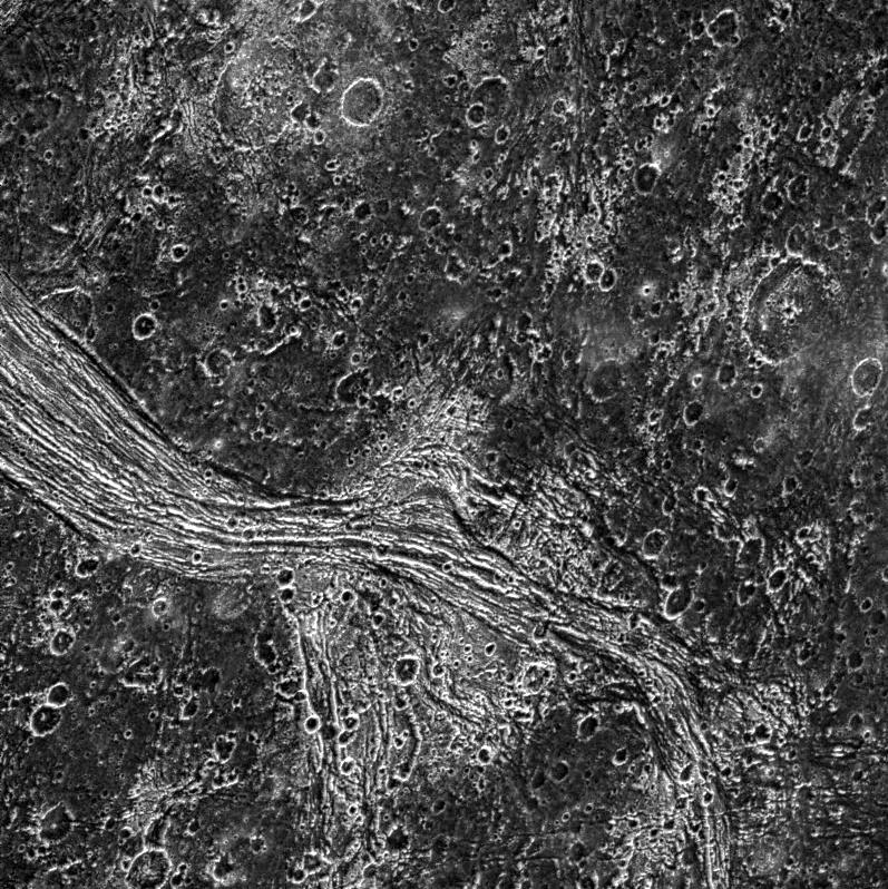
New terrain overlays older terrain, which overlays still older surface, in
this view of part of the surface of Jupiter's moon Ganymede, taken by the
camera onboard NASA's Galileo spacecraft. Galileo obtained the images that
make up this mosaic when it flew past Jupiter's moon Ganymede for the second
time on September 6, 1996. An area about 54 kilometers (33 miles) wide and
90 kilometers (55 miles) high is shown. Northern Marius Regio (the dark terrain
at bottom), Philus Sulcus (bright terrain at center), and Nippur Sulcus (bright
terrain at top) are seen illuminated by the Sun from the southeast (north
is at the top).
The key characteristics and relationships of the major terrain types on tectonically
active Ganymede are seen at a resolution 16 times better than images taken
by the Voyager spacecraft in 1979. At the bottom, the ancient dark terrain
is seen to be very deformed by tectonic fractures and faults. An impact crater
about 18 kilometers (about 11 miles) in diameter has been highly modified
by faulting. More recent cross-cutting fractures and faults at center illustrate
to scientists the sequence of events that have created the younger bright
terrain. The lines in the middle left of the image are faults that are cross-cut
by younger faults in the upper part of the image. The smooth band in the upper
middle of the image may represent water-ice volcanic deposits flooding a fault
valley. Clusters of small craters, representing ejecta transported from distant
craters and re-impacting here, are seen in the middle of the photo. The images
that make up this mosaic were taken at a range of about 11,620 kilometers
(about 7,200 miles).
The Jet Propulsion Laboratory, Pasadena, CA, manages the mission for NASA's
Office of Space Science, Washington, DC. This image and other images and data
received from Galileo are posted on the Galileo mission home page on the World
Wide Web at http://galileo.jpl.nasa.gov. Background information and educational
context for the images can be found at http://www.jpl.nasa.gov/galileo/sepo
Image Note: Division of Planetary Sciences Press Conference
 PIA00500.jpg
Original Caption Released with Image:
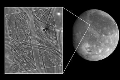
Galileo has eyes that can see more than ours can. By looking at what we call
the infrared wavelengths, the NIMS (Near Infrared Mapping Spectrometer) instrument
can determine what type and size of material is on the surface of a moon.
Here, 3 images of Ganymede are shown.
Left: Voyager's camera.
Middle: NIMS, showing water ice on the surface. Dark is less water, bright
is more.
Right: NIMS, showing the locations of minerals in red, and the size of ice
grains in shades of blue.
This image and other images and data received from Galileo are posted on the
World Wide Web, on the Galileo mission home page at URL http://galileo.jpl.nasa.gov.
Image Note: Science Magazine, Volume 274, Number 5286, 18 October 1996, pp
385-388 (figure 7) Galileo Ganymede 1 Orbit
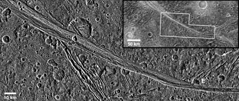
 PIA00579.jpg
Original Caption Released with Image:
A mosaic of four Galileo high-resolution images of the Uruk Sulcus region
of Jupiter's moon Ganymede (Latitude 11 N, Longitude: 170 W) is shown within
the context of an image of the region taken by Voyager 2 in 1979, which in
turn is shown within the context of a full-disk image of Ganymede. North is
to the top of the picture, and the sun illuminates the surface from the lower
left, nearly overhead. The area shown is about 120 by 110 kilometers (75 by
68 miles) in extent and the smallest features that can be discerned are 74
meters (243 feet) in size in the Galileo images and 1.3 kilometers (0.8 miles)
in the Voyager data. The higher resolution Galileo images unveil the details
of parallel ridges and troughs that are principal features in the brighter
regions of Ganymede. High photometric activity (large light contrast at high
spatial frequencies) of this ice-rich surface was such that the Galileo camera's
hardware data compressor was pushed into truncating lines. The north-south
running gap between the left and right halves of the mosaic is a result of
line truncation from the normal 800 samples per line to about 540. The images
were taken on 27 June, 1996 Universal Time at a range of 7,448 kilometers
(4,628 miles) through the clear filter of the Galileo spacecraft's imaging
system.
Launched in October 1989, Galileo entered orbit around Jupiter on December
7, 1995. The spacecraft's mission is to conduct detailed studies of the giant
planet, its largest moons and the Jovian magnetic environment.
The Jet Propulsion Laboratory manages the Galileo mission for NASA's Office
of Space Science, Washington, DC.
This image and other images and data received from Galileo are posted on the
World Wide Web Galileo mission home page at http://galileo.jpl.nasa.gov. Background
information and educational context for the images can be found at http://www.jpl.nasa.gov/galileo/sepo.
Image Note: Glileo Educator's Slide Set #2
 PIA00706.jpg
Original Caption Released with Image:
View of Ganymede from the Galileo spacecraft during its first encounter with
the Satellite. North is to the top of the picture and the sun illuminates
the surface from the right. The finest details that can be discerned in this
picture are about 6.7 kilometers across. The Universal Time is 8:45:09 UT
on June 26, 1996. The Jet Propulsion Laboratory, Pasadena, CA manages the
mission for NASAs Office of Space Science, Washington , DC. This image and
other images and data received from Galileo are posted on the World Wide Web,
on the Galileo mission home page at URL http://galileo.jpl.nasa.gov. Background
information and educational context for the images can be found at URL http://www.jpl.nasa.gov/galileo/sepo
Image Note: old mrps 76024
 PIA00707.jpg
Original Caption Released with Image:
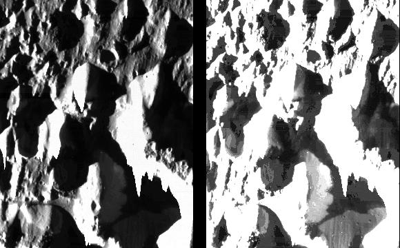
Dramatic view of fine details in ice hills and valleys in an unnamed region
on Jupiter's moon Ganymede. North is to the top of the picture and the sun
illuminates the surface from the left. The finest details that can discerned
in this picture are only 11 meters across (similar to the size of an average
house) some 2000 times better than previous images of this region. The bright
areas in the left hand version are the sides of hills facing the sun; the
dark areas are shadows. In the right hand version the processing has been
changed to bring out details in the shadowed regions that are illuminated
by the bright hillsides. The brightness of some of the hillsides is so high
that the picture elements 'spill over' down the columns of the picture. The
image was taken on June 28, 1996 from a distance of about 1000 kilometers.
The Jet Propulsion Laboratory, Pasadena, CA manages the mission for NASA's
Office of Space Science, Washington , DC. This image and other images and
data received from Galileo are posted on the World Wide Web, on the Galileo
mission home page at URL http://galileo.jpl.nasa.gov. Background information
and educational context for the images can be found at URL http://www.jpl.nasa.gov/galileo/sepo
Image Note: old mrps 76025
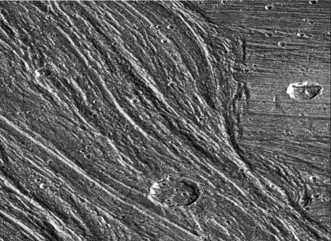 PIA01086.jpg
Original Caption Released with Image:
Complex sets of ridges and grooves are visible in this image of the Nippur
Sulcus region on Jupiter's largest moon Ganymede. NASA's Galileo spacecraft
imaged this region as it passed Ganymede during its second orbit through the
Jovian system. The Nippur Sulcus region is an example of Bright Terrain on
Ganymede which is typified by multiple sets of ridges and grooves. The intersections
of these sets reveal complex age relationships. North is to the top of the
picture and the sun illuminates the surface from the southeast (lower right).
In this image a younger sinuous northwest-southeast trending groove set cuts
through and apparently destroys the older east-west trending features on the
right of the image, allowing scientists to determine the sequence of events
that led to the region's formation. The area contains many impact craters.
The large crater in the bottom of the image is about 12 kilometers (8 miles)
in diameter.
The image, centered at 51 degrees latitude and 204 degrees longitude, covers
an area approximately 79 kilometers (50 miles) by 57 kilometers (36 miles)
across. The resolution is 93 meters (330 feet) per picture element. The images
were taken on September 6, 1996 at a range of 9,971 kilometers (6,232 miles)
by the solid state imaging (CCD) system on NASA's Galileo spacecraft.
The Jet Propulsion Laboratory, Pasadena, CA manages the Galileo mission for
NASA's Office of Space Science, Washington, DC. JPL is an operating division
of California Institute of Technology (Caltech).
This image and other images and data received from Galileo are posted on the
World Wide Web, on the Galileo mission home page at URL http://galileo.jpl.nasa.gov.
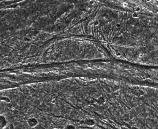 PIA01087.jpg
Original Caption Released with Image:
This image shows some unusual features on the surface of Jupiter's moon, Ganymede.
NASA's Galileo spacecraft imaged this region as it passed Ganymede during
its second orbit through the Jovian system. The region is located at 31 degrees
latitude, 186 degrees longitude in the north of Marius Regio, a region of
ancient dark terrain, and is near the border of a large swathe of younger,
heavily tectonised bright terrain known as Nippur Sulcus. Situated in the
transitional region between these two terrain types, the area shown here contains
many complex tectonic structures, and small fractures can be seen crisscrossing
the image. North is to the top-left of the picture, and the sun illuminates
the surface from the southeast. This image is centered on an unusual semicircular
structure about 33 kilometers (20 miles) across. A 38 kilometer (24 mile)
long, remarkably linear feature cuts across its northern extent, and a wide
east-west fault system marks its southern boundary. The origin of these features
is the subject of much debate among scientists analyzing the data. Was the
arcuate structure part of a larger feature? Is the straight lineament the
result of internal or external processes? Scientists continue to study this
data in order to understand the surface processes occuring on this complex
satellite.
The image covers an area approximately 80 kilometers (50 miles) by 52 kilometers
(32 miles) across. The resolution is 189 meters (630 feet) per picture element.
The images were taken on September 6, 1996 at a range of 9,971 kilometers
(6,232 miles) by the solid state imaging (CCD) system on NASA's Galileo spacecraft.
The Jet Propulsion Laboratory, Pasadena, CA manages the Galileo mission for
NASA's Office of Space Science, Washington, DC. JPL is an operating division
of California Institute of Technology (Caltech).
This image and other images and data received from Galileo are posted on the
World Wide Web, on the Galileo mission home page at URL http://galileo.jpl.nasa.gov.
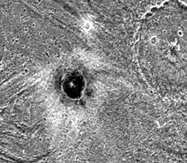 PIA01090.jpg
Original Caption Released with Image:
The dark-floored crater, Khensu, is the target of this image of Ganymede.
The solid state imaging camera on NASA's Galileo spacecraft imaged this region
as it passed Ganymede during its second orbit through the Jovian system. Khensu
is located at 2 degrees latitude and 153 degrees longitude in a region of
bright terrain known as Uruk Sulcus, and is about 13 kilometers (8 miles)
in diameter. Like some other craters on Ganymede, it possesses an unusually
dark floor and a bright ejecta blanket. The dark component may be residual
material from the impactor that formed the crater. Another possibility is
that the impactor may have punched through the bright surface to reveal a
dark layer beneath.
Another large crater named El is partly visible in the top-right corner of
the image. This crater is 54 kilometers (34 miles) in diameter and has a small
'pit' in its center. Craters with such a 'central pit' are common across Ganymede
and are especially intriguing since they may reveal secrets about the structure
of the satellite's shallow subsurface.
North is to the top-left of the picture and the sun illuminates the surface
from nearly overhead. The image covers an area about 100 kilometers (62 miles)
by 86 kilometers (54 miles) across at a resolution of 111 meters (370 feet)
per picture element. The image was taken on September 6, 1996 by the solid
state imaging (CCD) system on NASA's Galileo spacecraft.
The Jet Propulsion Laboratory, Pasadena, CA manages the Galileo mission for
NASA's Office of Space Science, Washington, DC. JPL is an operating division
of California Institute of Technology (Caltech).
This image and other images and data received from Galileo are posted on the
World Wide Web, on the Galileo mission home page at URL http://galileo.jpl.nasa.gov.
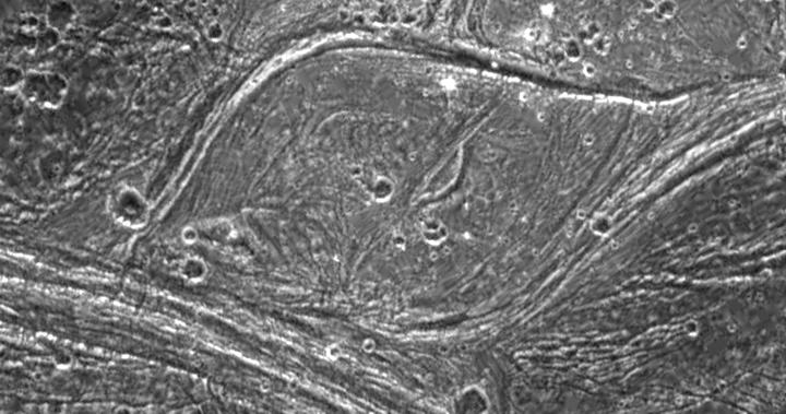 PIA01091.jpg
Original Caption Released with Image:
Complex tectonism is evident in these images of Ganymede's surface. The solid
state imaging camera on NASA's Galileo spacecraft imaged this region as it
passed Ganymede during its second orbit through the Jovian system. The 80
kilometer (50 mile) wide lens-shaped feature in the center of the image is
located at 32 degrees latitude and 188 degrees longitude along the border
of a region of ancient dark terrain known as Marius Regio, and is near an
area of younger bright terrain named Nippur Sulcus. The tectonism that created
the structures in the bright terrain nearby has strongly affected the local
dark terrain to form unusual structures such as the one shown here. The lens-like
appearance of this feature is probably due to shearing of the surface, where
areas have slid past each other and also rotated slightly. Note that in several
places in these images, especially around the border of the lens-shaped feature,
bright ridges appear to turn into dark grooves. Analysis of the geologic structures
in areas like this are helping scientists to understand the complex tectonic
history of Ganymede.
North is to the top-left of the image, and the sun illuminates the surface
from the southeast. The image covers an area about 63 kilometers (39 miles)
by 120 kilometers (75 miles) across at a resolution of 188 meters (627 feet)
per picture element. The images were taken on September 6, 1996 at a range
of 18,522 kilometers (11,576 miles) by the solid state imaging (CCD) system
on NASA's Galileo spacecraft.
The Jet Propulsion Laboratory, Pasadena, CA manages the Galileo mission for
NASA's Office of Space Science, Washington, DC. JPL is an operating division
of California Institute of Technology (Caltech).
This image and other images and data received from Galileo are posted on the
World Wide Web, on the Galileo mission home page at URL http://galileo.jpl.nasa.gov.
 PIA01607.jpg
Original Caption Released with Image:
View of two impact craters that are superimposed on Memphis Facula, a large
bright circular feature in the otherwise generally dark terrain in Galileo
Regio on Jupiter's moon, Ganymede. These are thought to be impact craters
because they share many of the features of such structures on other planets,
including steep walls, flat floors, and central mountain peaks. Bright icy
material is exposed on the walls, rims and peaks of these features and darker
material can be seen covering the floors and streaming down the inner walls
of the craters. The dark material may have been concentrated on the crater
floors during the impact events. A dark line near the crater rim may be exposures
of layered bedrock which has been uplifted. These craters have been degraded
to the degree that their ejecta and surrounding secondary crater fields are
no longer visible. The crater on the left (Chrysor) is about 6 kilometers
(km) in diameter and the larger one on the right (Aleyn) is about 12 km wide.
Smaller craters are seen as bright circles on the crater floors and in the
surrounding areas. The density of these superposed impact features allows
scientists to estimate the age of the surface and the age of the craters,
thought to be many hundreds of millions of years old. Memphis Facula, a large
350 km diameter bright feature on which the craters are situated, appears
to have formed from the excavation of bright water ice material during an
ancient, large impact event.
North is to the top left of the picture and the sun illuminates the surface
from the bottom. The image, centered at 15 degrees latitude and 134 degrees
longitude, covers an area approximately 23 by 23 kilometers. The resolution
is 59 meters per picture element. The image was taken on June 27, 1996 at
6 hours, 21 minutes, 19 seconds Universal Time at a range of 2849 kilometers
by the Solid State Imaging (SSI) system on NASA's Galileo spacecraft.
The Jet Propulsion Laboratory, Pasadena, CA manages the Galileo mission for
NASA's Office of Space Science, Washington, DC.
This image and other images and data received from Galileo are posted on the
World Wide Web, on the Galileo mission home page at URL NASA Product/Services
Source List
 PIA01608.jpg
Original Caption Released with Image:
During Galileo's second orbit, a series of images were obtained within the
northern polar cap of Jupiter's moon, Ganymede, across a north-south trending
boundary between the grooved terrain of Philae Sulcus and the dark terrain
of Galileo Regio. The blurry appearing background of this scene is the best
Voyager image of the area, at a resolution of about 1.4 kilometers per picture
element. The Voyager data shows that the grooved terrain of Philae Sulcus
to the west (left) is bright, and the older terrain of Galileo Regio to the
east (right) is dark; however, this brightness difference is not at all apparent
in the high resolution Galileo images. Instead, bright and dark patches occur
in both Philae Sulcus and in Galileo Regio. The bright patches occur mostly
on the north and east facing slopes of craters and ridges , which are expected
to be colder, and therefore to collect frost in this high latitude region.
The principal way that Ganymede's terrain types can be distinguished in the
high resolution Galileo images is by their texture: the "bright"
grooved terrain shows north-south trending ridges and grooves, and the ancient
"dark" terrain shows a rolling appearance and is more heavily cratered.
North is to the top of the picture and the sun illuminates the surface from
the lower right. The image, centered at 63 degrees latitude and 168 degrees
longitude, covers an area approximately 94 by 64 kilometers. The finest details
that can discerned in this picture are about 92 meters across. The images
were taken on September 6, 1996 beginning at 18 hours, 52 minutes, 46 seconds
Universal Time at a range of 2266 kilometers by the Solid State Imaging (SSI)
system on NASA's Galileo spacecraft.
The Jet Propulsion Laboratory, Pasadena, CA manages the Galileo mission for
NASA's Office of Space Science, Washington, DC.
This image and other images and data received from Galileo are posted on the
World Wide Web, on the Galileo mission home page at URL http:// galileo.jpl.nasa.gov
. Background information and educational context for the images can be found
at URL http://www.jpl.nasa.gov/galileo/sepo
 PIA01609.jpg
Original Caption Released with Image:
Oblique view of two fresh impact craters in bright grooved terrain near the
north pole of Jupiter's moon, Ganymede. The craters postdate the grooved terrain
since each is surrounded by swarms of smaller craters formed by material which
was ejected out of the crater as it formed, and which subsequently reimpacted
onto the surrounding surface. The crater to the north, Gula, which is 38 kilometers
(km) in diameter, has a distinctive central peak, while the crater to the
south, Achelous, (32 km in diameter) has an outer lobate ejecta deposit extending
about a crater radius from the rim. Such images show the range of structural
details of impact craters, and help in understanding the processes that form
them.
North is to the top of the picture and the sun illuminates the surface from
the right. The image, centered at 62 degrees latitude and 12 degrees longitude,
covers an area approximately 142 by 132 kilometers. The resolution is 175
meters per picture element. The images were taken on April 5, 1997 at 6 hours,
33 minutes, 37 seconds Universal Time at a range of 17,531 kilometers by the
Solid State Imaging (SSI) system on NASA's Galileo spacecraft.
The Jet Propulsion Laboratory, Pasadena, CA manages the Galileo mission for
NASA's Office of Space Science, Washington, DC.
This image and other images and data received from Galileo are posted on the
World Wide Web, on the Galileo mission home page at URL http:// galileo.jpl.nasa.gov
. Background information and educational context for the images can be found
at URL http://www.jpl.nasa.gov/galileo/sepo
 PIA01610.jpg
Original Caption Released with Image:
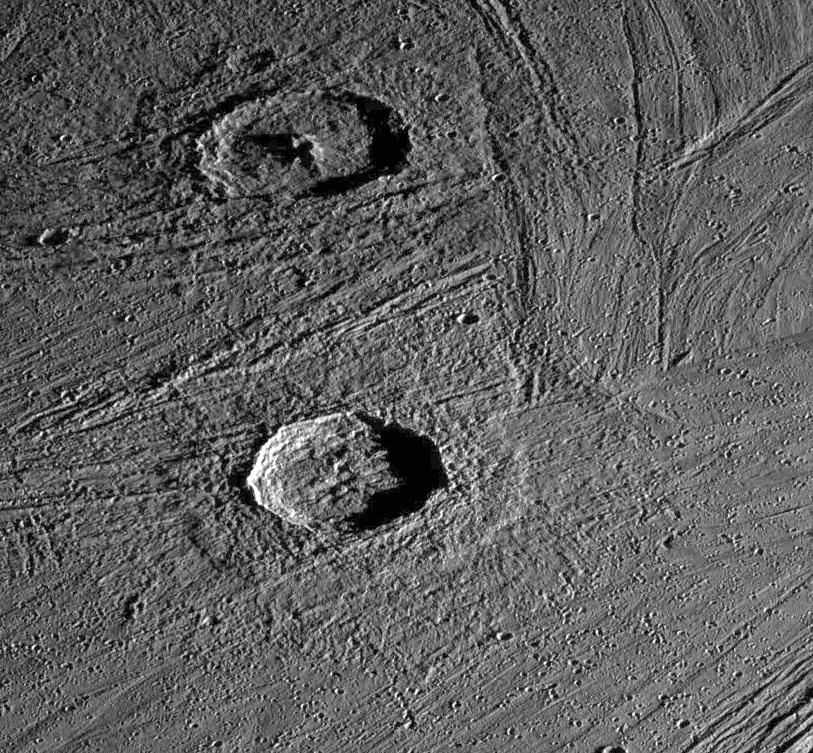
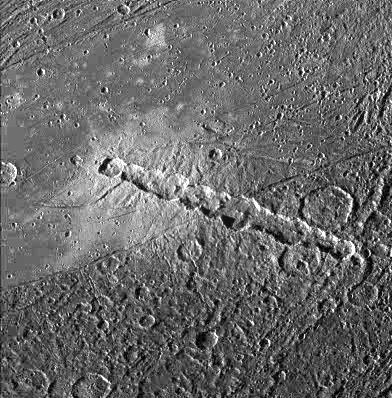
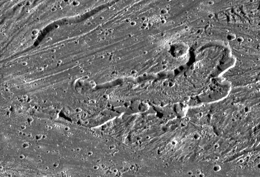
View of a chain of craters named Enki Catena on Jupiter's moon, Ganymede.
This chain of 13 craters probably formed by a comet which was pulled into
pieces by Jupiter'’s gravity as it passed too close to the planet. Soon
after this breakup, the 13 fragments crashed onto Ganymede in rapid succession.
The Enki craters formed across the sharp boundary between areas of bright
terrain and dark terrain, delimited by a thin trough running diagonally across
the center of this image. The ejecta deposit surrounding the craters appears
very bright on the bright terrain. Even though all the craters formed nearly
simultaneously, it is difficult to discern any ejecta deposit on the dark
terrain. This may be because the impacts excavated and mixed dark material
into the ejecta and the resulting mix is not apparent against the dark background.
North is to the bottom of the picture and the sun illuminates the surface
from the left. The image, centered at 39 degrees latitude and 13 degrees longitude,
covers an area approximately 214 by 217 kilometers. The resolution is 545
meters per picture element. The image was taken on April 5, 1997 at 6 hours,
12 minutes, 22 seconds Universal Time at a range of 27282 kilometers by the
Solid State Imaging (SSI) system on NASA's Galileo spacecraft.
The Jet Propulsion Laboratory, Pasadena, CA manages the Galileo mission for
NASA's Office of Space Science, Washington, DC.
This image and other images and data received from Galileo are posted on the
World Wide Web, on the Galileo mission home page at URL http:// galileo.jpl.nasa.gov
. Background information and educational context for the images can be found
at URL http://www.jpl.nasa.gov/galileo/sepo
 PIA01612.jpg
Original Caption Released with Image:
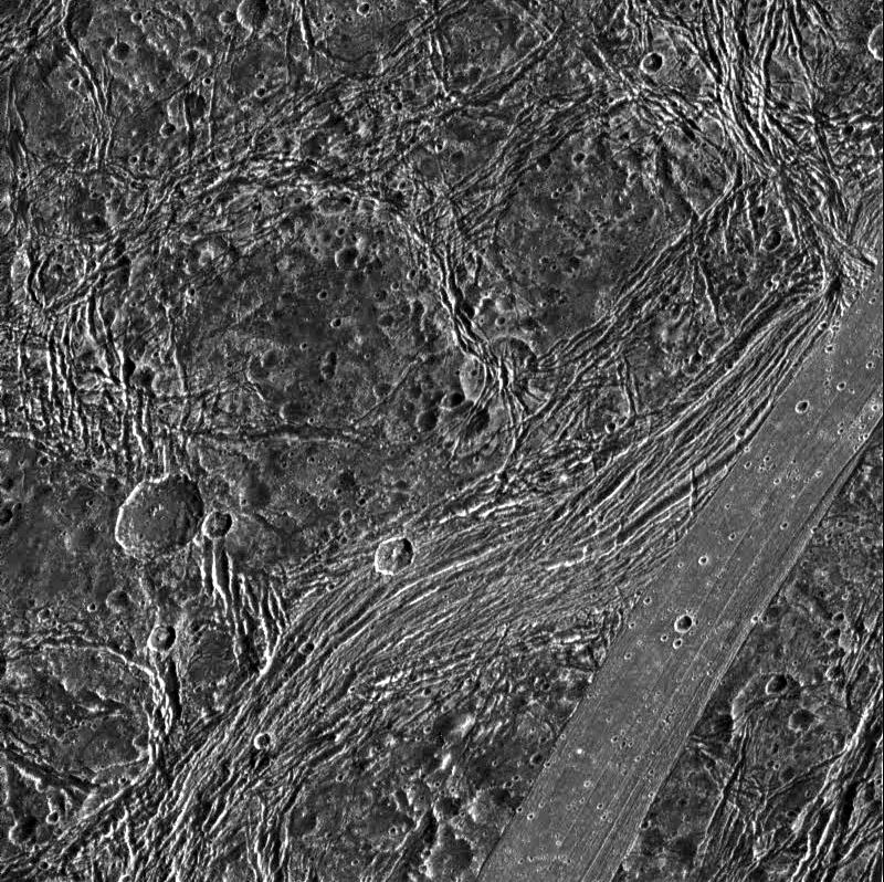
Dark terrain of Nicholson Regio on Jupiter's moon, Ganymede. On the left is
a crater that has been torn apart by tectonic forces. A lane of ridges and
grooves (probably extensional fault blocks) cuts through the crater and distorts
its originally circular shape. Though such deformation is more typical of
Ganymede's bright grooved terrain, this image demonstrates that extreme tectonic
disruption has occurred in the satellite's dark terrain also. The pair of
oblong craters on the right was formed by the impact of a gravitationally
bound pair of asteroids or a split comet. The oblong shapes of the craters
suggest that the impactors struck the surface at a shallow angle. Toward the
top left, an old crater has been partially buried by dark ejecta tossed from
another impact about 50 kilometers to the north of this image.
North is to the top of the picture and the sun illuminates the surface from
the right. The image, centered at 14 degrees south latitude and 352 degrees
longitude, covers an area approximately 111 by 93 kilometers. The resolution
is 180 meters per picture element. The image was taken on April 5, 1997 at
6 hours, 31 minutes, 44 seconds Universal Time at a range of 17,840 kilometers
by the Solid State Imaging (SSI) system on NASA's Galileo spacecraft.
The Jet Propulsion Laboratory, Pasadena, CA manages the Galileo mission for
NASA's Office of Space Science, Washington, DC.
This image and other images and data received from Galileo are posted on the
World Wide Web, on the Galileo mission home page at URL http://galileo.jpl.nasa.gov
. Background information and educational context for the images can be found
at URL http://www.jpl .nasa.gov/galileo/sepo
 PIA01613.jpg
Original Caption Released with Image:
View of Nicholson Regio on Jupiter's moon, Ganymede, showing heavily fractured
dark terrain and a lane of smooth bright terrain. North is to the top of the
picure. A smooth, linear plank-like strip of bright terrain cuts across the
southeast (lower right) corner of the image. Just west (left) of this is a
very heavily fractured lane of dark terrain, curving towards the south. This
fractured lane looks bright in lower resolution Voyager images and may be
transitional between the older, heavily fractured dark terrain, and younger,
less densely cratered bright terrain. The many other fractures visible within
the dark terrain probably result from extension in the area. Some of these
fractures were focused around weaknesses created by older craters (such as
the one just east of the image center).
The sun illuminates the surface from the right. The image, centered at 14
degrees south latitude and 352 degrees longitude, covers an area approximately
144 by 144 kilometers. The resolution is 180 meters per picture element. The
image was taken on April 5, 1997 at 6 hours, 31 minutes, 35 seconds Universal
Time at a range of 17,842 kilometers by the Solid State Imaging (SSI) system
on NASA's Galileo spacecraft.
The Jet Propulsion Laboratory, Pasadena, CA manages the Galileo mission for
NASA's Office of Space Science, Washington, DC.
This image and other images and data received from Galileo are posted on the
World Wide Web, on the Galileo mission home page at URL NASA Product/Services
Source List
 PIA01614.jpg
Original Caption Released with Image:
NASA's Galileo imaging camera targeted an area in Sippar Sulcus on Jupiter's
moon, Ganymede. Images obtained in 1979 by NASA's Voyager spacecraft showed
that the area contained curvilinear and arcuate scarps or cliffs. These features
appeared to be depressions which were candidate sources for some of the water
ice volcanism thought to form the bright grooved terrain on Ganymede. The
high resolution Galileo images seen here reveal that one of these structures
contains a lobate, flow-like feature that is the best candidate yet seen for
an icy volcanic lava flow on Ganymede. The prominent depression with scalloped
walls and internal terraces is about 55 kilometers (km) in length and 17 to
20 km wide. On the floor of the inner depression is a lobate flow-like deposit
7 to 10 km wide with ridges that are curved outward (and apparently downslope)
toward a cross-cutting lane of grooved terrain. The morphology of this structure
suggests the possibility of volcanic eruptions creating a channel and flow,
and cutting down into the surface.
North is to the bottom of the picture and the sun illuminates the surface
from the left. The mosaic, centered at 31 degrees south latitude and 189 degrees
longitude, covers an area approximately 91 by 62 kilometers. The resolution
is 172 meters per picture element. The images were taken on May 7, 1997 at
15 hours, 18 minutes, 35 seconds Universal Time at a range of 17,489 kilometers
by the Solid State Imaging(SSI) system on NASA's Galileo spacecraft.
The Jet Propulsion Laboratory, Pasadena, CA manages the Galileo mission for
NASA's Office of Space Science, Washington, DC.
This image and other images and data received from Galileo are posted on the
World Wide Web, on the Galileo mission home page at URL http://galileo.jpl.nasa.gov
. Background information and educational context for the images can be found
at URL http://www.jpl .nasa.gov/galileo/sepo
 PIA01616.jpg
Original Caption Released with Image:
View of a boundary between bright and dark terrain at the southern border
of Galileo Regio on Jupiter's moon, Ganymede. A narrow, 15 kilometer wide,
band of fractured bright terrain runs from the upper left to lower right of
this image. The dark terrain on either side of this band of bright terrain
has been highly fractured in multiple directions by tectonic activity. The
large bright circular feature in the upper right is probably an impact crater
that has been topographically relaxed, perhaps indicating that the subsurface
was warm in this region at some point in its history before the formation
of the bright terrain. Such images help determine how the ancient dark terrain
on Ganymede was converted into younger bright terrain.
North is to the top of the picture and the sun illuminates the surface from
nearly overhead. The image, centered at 7 degrees latitude and 157 degrees
longitude, covers an area approximately 81 by 58 kilometers. The resolution
is 160 meters per picture element. The image was taken on May 7, 1997 at 15
hours, 21 minutes, 16 seconds Universal Time at a range of 16218 kilometers
by the Solid State Imaging (SSI) system on NASA's Galileo spacecraft.
The Jet Propulsion Laboratory, Pasadena, CA manages the Galileo mission for
NASA's Office of Space Science, Washington, DC.
This image and other images and data received from Galileo are posted on the
World Wide Web, on the Galileo mission home page at URL ihttp://galileo.jpl.nasa.gov
. Background information and educational context for the images can be found
at URL http://www.jpl.nasa.gov/galileo/sepo
 PIA01617.jpg
Original Caption Released with Image:
This image shows a highly fractured lane of grooved terrain, Lagash Sulcus,
which runs through an area of heavily cratered dark terrain within Marius
Regio on Jupiter's moon Ganymede. The boundary between these two units is
marked by a deep trough. Outside the groove lane, little fracturing is evident,
suggesting that deformation is largely concentrated within the bright grooved
area. The bright, heart-shaped feature just below the image center may be
a patch of bright terrain, or the feature may be related to ancient impact
event.
North is to the top of the picture and the sun illuminates the surface from
the upper right. The image, centered at 17 degrees south latitude and 156
degrees longitude, covers an area approximately 230 by 230 kilometers. The
resolution is 288 meters per picture element. The images were taken on June
6, 1997 at 14 hours, 56 minutes, 11 seconds Universal Time at a range of 28655
kilometers by the Solid State Imaging (SSI) system on NASA's Galileo spacecraft.
The Jet Propulsion Laboratory, Pasadena, CA manages the Galileo mission for
NASA's Office of Space Science, Washington, DC.
This image and other images and data received from Galileo are posted on the
World Wide Web, on the Galileo mission home page at URL http:// galileo.jpl.nasa.gov
. Background information and educational context for the images can be found
at URL http://www.jpl.nasa.gov/galileo/sepo
 PIA01618.jpg
Original Caption Released with Image:
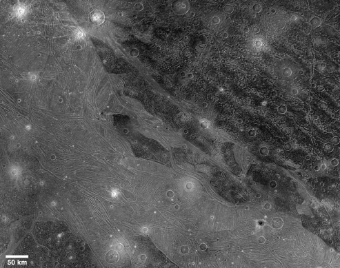
View of the Marius Regio and Nippur Sulcus area of Jupiter's moon, Ganymede
showing the dark and bright grooved terrain which is typical of this satellite.
This regional scale view was imaged near the terminator (the line between
day and night) and provides geologic context for small areas that were imaged
at much higher resolution earlier in the tour of NASA's Galileo spacecraft
through the Jovian system. The older, more heavily cratered dark terrain of
Marius Regio is rutted with furrows, shallow troughs perhaps formed as a result
of ancient giant impacts. Bright grooved terrain is younger and is formed
through tectonism probably combined with icy volcanism. The lane of grooved
terrain in the lower left, Byblus Sulcus , was imaged during the spacecraft's
second orbit, as were Philus Sulcus and Nippur Sulcus , seen here in the upper
left. Placing the small higher resolution targets of Galileo's second orbit
into the context of more distant, lower resolution views of the areas surrounding
and connecting them, and imaging them along Ganymede's terminator, allows
for an integrated understanding of Ganymede' s geology.
North is to the top left of the picture and the sun illuminates the surface
from the lower right. The image, centered at 43 degrees latitude and 194 degrees
longitude, covers an area approximately 664 by 518 kilometers. The resolution
is 940 meters per picture element. The image was taken on May 7, 1997 at 12
hours, 50 minutes, 11 seconds Universal Time at a range of 92,402 kilometers
by the Solid State Imaging (SSI) system on NASA's Galileo spacecraft.
The Jet Propulsion Laboratory, Pasadena, CA manages the Galileo mission for
NASA's Office of Space Science, Washington, DC.
This image and other images and data received from Galileo are posted on the
World Wide Web, on the Galileo mission home page at URL http://galileo.jpl.nasa.gov
. Background information and educational context for the images can be found
at URL http://www.jpl .nasa.gov/galileo/sepo
 PIA01619.jpg
Original Caption Released with Image:
View of the Tiamat Sulcus region on Jupiter's moon, Ganymede, imaged just
after local sunrise. The illumination from such a low sun angle highlights
the grooved topography of Tiamat. Furrows and fractures are apparent in the
surrounding dark terrain also. North-south trending Tiamat Sulcus is divided
in two by Kishar Sulcus, which trends east-west. The southern portion of Tiamat
is wider than its northern portion, indicating that there has been a greater
degree of extension south of Kishar Sulcus than north of it. The portion of
Kishar Sulcus to the right of Tiamat Sulcus appears to have slid horizontally
(with respect to the left portion of Kishar Sulcus) along a northwest-southeast
trending strike-slip fault.
North is to the top of the picture and the sun illuminates the surface from
the right. The image, centered at 1 degree south latitude and 204 degrees
longitude, covers an area approximately 386 by 387 kilometers. The resolution
is 494 meters per picture element. The image was taken on May 7, 1997 at 14
hours, 15 minutes, 7 seconds Universal Time at a range of 48,859 kilometers
by the Solid State Imaging (SSI) system on NASA's Galileo spacecraft.
The Jet Propulsion Laboratory, Pasadena, CA manages the Galileo mission for
NASA's Office of Space Science, Washington, DC.
This image and other images and data received from Galileo are posted on the
World Wide Web, on the Galileo mission home page at URL http://galileo.jpl.nasa.gov
. Background information and educational context for the images can be found
at URL http://www.jpl .nasa.gov/galileo/sepo
 PIA01666.jpg
Original Caption Released with Image:
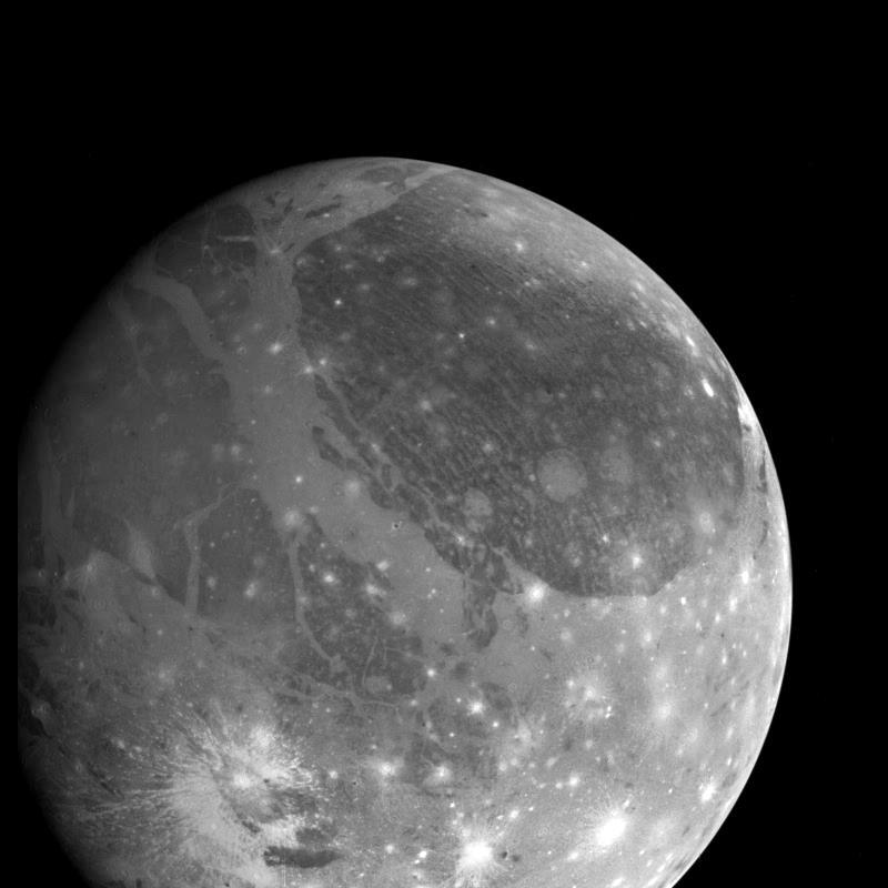
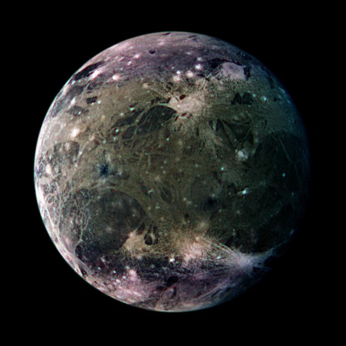
In this global view of Ganymede's trailing side, the colors are enhancedto
emphasize color differences. The enhancement reveals frosty polar capsin addition
to the two predominant terrains on Ganymede, bright, grooved terrain and older,
dark furrowed areas. Many craters with diametersup to several dozen kilometers
are visible. The violet hues at the polesmay be the result of small particles
of frost which would scatter more lightat shorter wavelengths (the violet
end of the spectrum). Ganymede's magnetic field, which was detected by the
magnetometer on NASA's Galileo spacecraft in 1996, may be partly responsible
for the appearance of thepolar terrain. Compared to Earth's polar caps, Ganymede's
polar terrain is relatively vast. The frost on Ganymede reaches latitudes
as low as 40 degrees on average and 25 degrees at some locations. For comparison
with Earth, Miami, Florida lies at 26 degrees north latitude, and Berlin,
Germany is located at 52 degrees north.
North is to the top of the picture. The composite, which combines images taken
with green, violet, and 1 micrometer filters, is centered at 306 degrees west
longitude. The resolution is 9 kilometers (6 miles) per picture element. The
images were taken on 29 March 1998 at a range of 918000 kilometers (570,000
miles) by the Solid State Imaging (SSI) system on NASA's Galileo spacecraft.
The Jet Propulsion Laboratory, Pasadena, CA manages the Galileo missionfor
NASA's Office of Space Science, Washington, DC.
This image and other images and data received from Galileo are postedon the
World Wide Web, on the Galileo mission home page at URL http://galileo.jpl.nasa.gov
. Background information andeducational context for the images can be found
at URL http://www.jpl.nasa.gov/galileo/sepo
 PIA02571.jpg
Original Caption Released with Image:
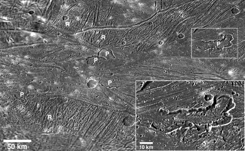
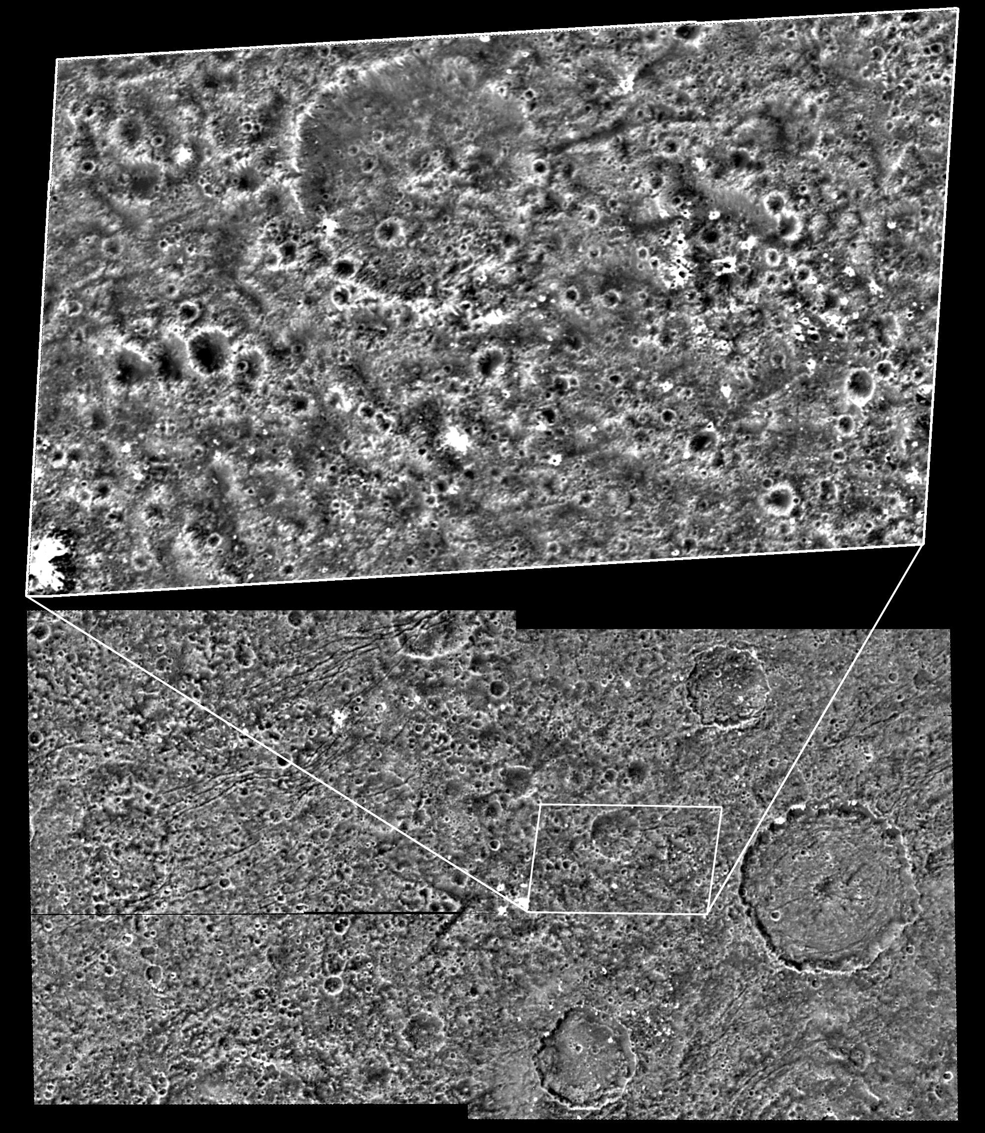
Impact craters dominate the surface down to the smallest featuresvisible on
the dark terrain of the Nicholson Regio region of Jupiter'smoon Ganymede in
this image taken by NASA's Galileo spacecraft. It isthe highest resolution
view ever obtained of Ganymede's dark terrain.
Both the regional-scale image at the bottom and high-resolution imageat the
top were taken by Galileo during its May 20, 2000, flyby ofGanymede. The latter
are the highest resolution images ever obtained ofGanymede's dark terrain,
which makes up about one third of Ganymede'ssurface.
Impact cratering is clearly the dominant mechanism of surfacemodification
in this relatively ancient terrain, which is analogous tothe cratered highlands
of Earth's Moon. Small-scale craters seem tomimic larger-scale craters, as
is apparent in the similarities betweenthe high and medium resolution scenes.
The bright spots are probablyfresh ice-rich ejecta excavated by the most recent
impact events.
North is to the top of the images and the Sun illuminates the surfacefrom
the west. The medium-resolution image, centered at ?15 degreeslatitude and
337 degrees longitude, covers an area approximately 237 by130 kilometers (147
by 81 miles) at a resolution of 125 meters (410feet) per picture element.
The high-resolution image is at 28 meters (92feet) per picture element.
This image and other images and data received from Galileo are postedon the
Galileo mission home page at http://www.jpl.nasa.gov/galileo .Background information
and educational context for the images can befound at http://www.jpl.nasa.gov/galileo/sepo
.
The Jet Propulsion Laboratory, a division of the California Instituteof Technology,
in Pasadena, manages the Galileo mission for NASA'sOffice of Space Science,
Washington, D.C.
The images were produced by Arizona State University, Tempe, and BrownUniversity,
Providence, R.I.. Their websites are at http://europa.la.asu.edu/index.html
and http://www.planetary.brown.edu/ .
 PIA02573.jpg
Original Caption Released with Image:
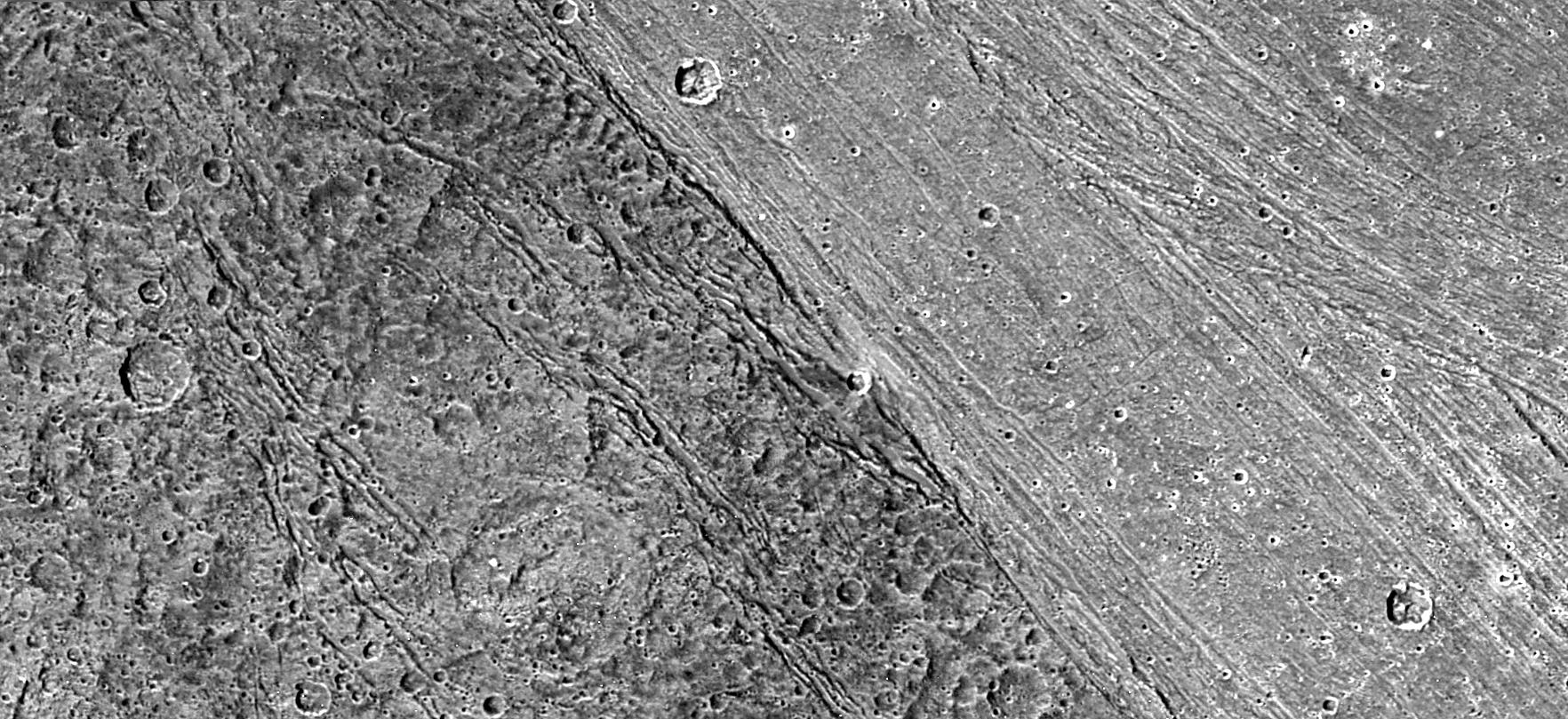
This view of the Nicholson Regio/Arbela Sulcus region on Jupiter's moonGanymede,
taken by NASA's Galileo spacecraft, shows the stark contrastbetween the smooth
bright terrain and the surrounding highly fractureddark terrain.
This observation was designed in part to distinguish between differentmodels
for how Arbela Sulcus and other groove lanes on Ganymede wereformed. The volcanic
model suggests that a relatively clean, water-richlava filled a tectonic depression,
then cooled to create a smoothsurface. Tectonic models suggest that focused
faulting and deformationof older dark terrain destroyed the pre-existing texture,
which wasbrightened by exposure of underlying, clean ice. Analysis of thesephotos
suggests a third and unexpected possibility: Arbela Sulcus may besimilar to
some bands on another of Jupiter's moons, Europa, formed bytectonic crustal
spreading and renewal.
North is to the upper left of the picture and the Sun illuminates thesurface
from the west. The image, centered at ?14 degrees latitude and347 degrees
longitude, covers an area approximately 258 by 116kilometers (160 by 72 miles).
The resolution is 133 meters (436 feet)per picture element. The images were
taken on May 20, 2000, at a rangeof 13,100 kilometers (8,140 miles).
This image and other images and data received from Galileo are posted onthe
Galileo mission home page at http://www.jpl.nasa.gov/galileo .Background information
and educational context for the images can befound at http://www.jpl.nasa.gov/galileo/sepo
.
The Jet Propulsion Laboratory, a division of the California Instituteof Technology
in Pasadena, manages the Galileo mission for NASA's Officeof Space Science,
Washington, D.C.
This image was produced by DLR (German Aerospace Center), Berlin, andBrown
University, Providence, R.I., http://solarsystem.dlr.de/ and http://www.planetary.brown.edu/
.
 PIA02577.jpg
Original Caption Released with Image:
The ancient, dark terrain of Nicholson Regio (left) shows many largeimpact
craters, and zones of fractures oriented generally parallel tothe boundary
between the dark and bright regions of Jupiter?s moonGanymede. In contrast,
the bright terrain of Harpagia Sulcus (right) isless cratered and relatively
smooth.
The nature of the boundary between ancient, dark terrain and younger,bright
terrain, the two principal terrain types on Ganymede, wasexplored by NASA?s
Galileo spacecraft on May 20, 2000. Subtle parallelridges and grooves show
that Harpagia Sulcus?s land has been smoothedout over the years by tectonic
processes.
North is to the top of the picture. The Sun illuminates the surface fromthe
left. The image, centered at ?14 degrees latitude and 319 degreeslongitude,
covers an area approximately 213 by 97 kilometers (132 by 60miles.) The resolution
is 121 meters (about 250 feet) per pictureelement. The images were taken on
May 20, 2000, at a range of 11,800kilometers (about 7,300 miles).
The Jet Propulsion Laboratory, Pasadena, Calif., manages the Galileomission
for NASA's Office of Space Science, Washington, D.C. JPL is adivision of the
California Institute of Technology in Pasadena.
This image and other images and data received from Galileo are posted onthe
Galileo mission home page at http://www.jpl.nasa.gov/galileo .Background information
and educational context for the images can befound at http://www.jpl.nasa.gov/galileo/sepo
.
This image was produced by DLR (German Aerospace Center), Berlin, http://solarsystem.dlr.de/
. PIA02578.jpg
Original Caption Released with Image:
The boundary between the bright terrain of Harpagia Sulcus (right) anddark
terrain of Nicholson Regio (left) areas of Jupiter?s moon Ganymedesprings
out when viewed through red/blue 3-D glasses, in this imagetaken by NASA?s
Galileo spacecraft as it flew by Ganymede on May 20,2000.
Details of the rough, ancient, heavily cratered dark terrain ofNicholson Regio
are in stark contrast to the very smooth, bright, youngterrain of Harpagia
Sulcus. In the center lies the transition to theboundary between these two
regions, providing evidence that extensionalfaulting marks the boundary. A
series of steep slopes deform the darkterrain close to the boundary. In the
bright terrain, a deep trough andflanking ridge delimit the boundary.
North is to the top of the picture. The Sun illuminates the surface fromthe
left. The imaged region, centered at ?14 degrees latitude and 319degrees longitude,
covers an area approximately 25 by 10 kilometers(15.5 by 6 miles.) The resolutions
of the two data sets are 20 meters(66 feet) per picture element and 121 meters
(397 feet) per pictureelement. The higher resolution images were taken at
a range of 2,000kilometers (about 1,200 miles).
The Jet Propulsion Laboratory, Pasadena, Calif., manages the Galileomission
for NASA's Office of Space Science, Washington, D.C. JPL is adivision of the
California Institute of Technology in Pasadena.
This image and other images and data received from Galileo are posted onthe
Galileo mission home page at http://www.jpl.nasa.gov/galileo . Theimage was
produced by the German Aerospace Center (DLR), http://solarsystem.dlr.de and
Brown University, http://www.planetary.brown.edu/ . Background information
and educationalcontext for the images can be found at http://www.jpl.nasa.gov/galileo/sepo
.
 PIA02579.jpg
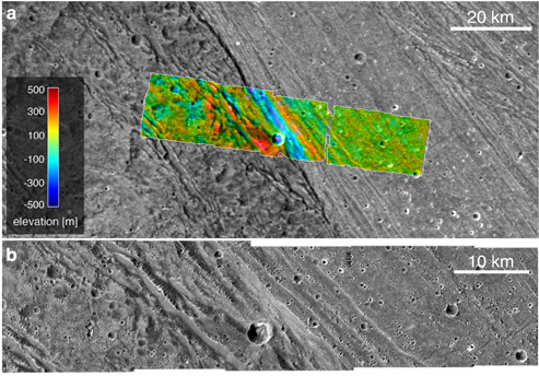
Original Caption Released with Image:
These images, taken by NASA's Galileo spacecraft on its May 20, 2000,flyby
of Jupiter?s moon Ganymede, illustrate the boundary and differentelevations
between the dark, ancient terrain of Nicholson Regio (left)and bright, younger
terrain of Harpagia Sulcus (right.) The bottom imageis a wide view of the
boundary, and the top image is an enlargement ofthe colorized strip.
An important goal of Galileo?s Ganymede encounter was to understand thenature
of the boundary between ancient, dark terrain and younger, brightterrain.
The camera was aimed at the boundary to obtain both veryhigh-resolution images
(top) and medium-resolution context images(bottom). Color-coded elevations
are indicated relative to the averageelevation of the sampled area, with high
elevation marked in red, andlow in blue. Combining the two image mosaics allows
scientists to derivea detailed description of the region from the overlap.
The data showsthat there are approximately 200 meters (about 650 feet) of
topographicrelief within the bright terrain here, and a deep depression marks
theboundary between bright and dark terrains.
North is to the top of the pictures. The Sun illuminates the surfacefrom the
left. The larger image, centered at ?14 degrees latitude and319 degrees longitude,
covers an area approximately 213 by 97 kilometers(132 by 60 miles.) The resolution
of the high-resolution image is 20meters (about 65 feet) per picture element,
and the context image is at121 meters (397 feet) per picture element. The
higher resolution imagewas taken at a range of 2000 kilometers (over 1,200
miles).
The Jet Propulsion Laboratory, Pasadena, Calif., manages the Galileomission
for NASA's Office of Space Science, Washington, D.C. JPL is adivision of the
California Institute of Technology in Pasadena.
This image and other images and data received from Galileo are posted onthe
Galileo mission home page at http://www.jpl.nasa.gov/galileo . Theimages were
produced by the German Aerospace Center (DLR) http://solarsystem.dlr.de/ ,
and Brown University, http://www.planetary.brown.edu/ . Background information
and educationalcontext for the images can be found at http://www.jpl.nasa.gov/galileo/sepo
.
 PIA02582.jpg
Original Caption Released with Image:
NASA's Galileo spacecraft took this image of dark terrain withinNicholson
Regio, near the border with Harpagia Sulcus on Jupiter's moonGanymede. The
ancient, heavily cratered dark terrain is faulted by aseries of scarps.
The faulted blocks form a series of 'stair-steps' like a tilted stack ofbooks.
On Earth, similar types of features form when tectonic faultingbreaks the
crust and the intervening blocks are pulled apart and rotate.This image supports
the notion that the boundary between bright and darkterrain is created by
that type of extensional faulting.
North is to the right of the picture and the Sun illuminates the surfacefrom
the west (top). The image is centered at -14 degrees latitude and320 degrees
longitude, and covers an area approximately 16 by 15kilometers (10 by 9 miles).
The resolution is 20 meters (66 feet) perpicture element. The image was taken
on May 20, 2000, at a range of2,090 kilometers (1,299 miles).
This image and other images and data received from Galileo are postedon the
Galileo mission home page at http://www.jpl.nasa.gov/galileo .Background information
and educational context for the images can befound at http://www.jpl.nasa.gov/galileo/sepo
.
The Jet Propulsion Laboratory, a division of the California Instituteof Technology
in Pasadena, manages the Galileo mission for NASA's Officeof Space Science,
Washington, D.C.
This image was produced by Brown University, Providence, R.I., http://www.planetary.brown.edu/
.