SEE Level 2B EGS Occultation Data
EGS Level 2B Occultation Data Directory – browse relevant files
EGS Level 2B Occultation Merged NetCDF file (single file) of the entire mission
Summary of EGS Solar Occultation Data
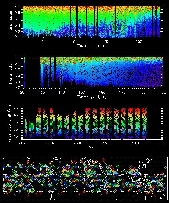
Top two figures show the atmospheric transmission as a function of wavelength from 27 nm to 190 nm. The color in these figures represent the tangent altitude of the occultation as shown in the third plot. The bottom plot shows the location on Earth for each measurement.
Detailed Level 2B EGS Occultation Description
README_EGS_L2B_OCC_012.TXT – information for using EGS_L2B occultation data
The EUV Grating Spectrograph (EGS) aboard SEE performs measurements of the Sun for about 3 minutes every orbit (97 minutes) which usually gives 14-15 measurements per day. 4x per year, in-between direct solar measurements, the SEE instrument has opportunities to observe the solar irradiance transmitted through the atmosphere. The Level 2B EGS Occultation data is time averaged over each measurement and divided by the average of the previous and next solar observations. The EGS resolution is about 0.4 nm, but the data product is sampled at 0.1 nm with valid data ranging from ~27-190 nm. Missing values are filled with -1.
A poster (Eparvier 2005) containing preliminary analysis results was presented at the fall 2005 AGU meeting and contains additional useful information.
Reading the Data with IDL
With read_netcdf.pro individual data files may be read using an IDL command such as:
read_netcdf,'see__egs_L2B_merged_2011099_012.ncdf',d,att
The data will then reside in the returned structure “d”, with each tag in the structure defined in the attributes array “att”.
SEE Level 2B EGS Occultation Software
- TIMED-SEE NetCDF README – Described IDL source code and gives examples using read_netcdf.pro and write_netcdf.pro
- read_netcdf.pro – IDL procedure for reading NetCDF files as a structure
- write_netcdf.pro – IDL procedure for writing a data structure (or array of structures) to a NetCDF file
- plot_occ_alt.pro – IDL procedure for plotting a time series of EGS Level 2B transmission data near a certain date (requires the mission merged file).
SEE Level 2B EGS Occultation Data Format
The data file contains a structure with 1 elements
L2B_EGS_DATA STRUCT = -> Array[1]
The L2B_EGS_DATA structure has the following form:
** Structure <2e29d8>, 12 tags, length=32375368, data length=32375368, refs=1:
   DATE            LONG      Array[1196]
   TIME            FLOAT     Array[1196]
   LS_TIME         FLOAT     Array[1196]
   TAN_PT_LAT      FLOAT     Array[1196]
   TAN_PT_LONG     FLOAT     Array[1196]
   TAN_PT_ALT      FLOAT     Array[1196]
   WAVE            FLOAT     Array[1690]
   TRANSMISSION    FLOAT     Array[1690, 1196]
   ERR_TOT         FLOAT     Array[1690, 1196]
   ERR_MEAS        FLOAT     Array[1690, 1196]
   STDEV_MEAS      FLOAT     Array[1690, 1196]
   VER             STRUCT    ->  Array[1]
Nested structure VER
** Structure <2f20d8>, 4 tags, length=64, data length=64, refs=2:
   CAL             STRING '09.01'
   SOFT            STRING '11.01'
   FORMAT          STRING '010'
   SDP             STRING '011'
NetCDF file attributes
GLOBAL:

    Title = SEE Level 2B EGS Occultation Time Series Data Product - EGS occultation
      ratio

    Source = SEE POC at LASP / CU

    Mission = TIMED

    Data_product_type = SEE EGS Level 2B Occultation Time Series

    Data_product_version = 011

    Data_product_revision = 01

    Software_version = 11.01

    Software_name = write_netCDF.pro called from time_series_egsl2b_add.pro

    Calibration_version = 09.01

    Description = Fractional Solar Irradiance transmitted during occultation

    History = 03/10/06 D. L. Woodraska Original file creation

    Filename = /titus/timed/data/merged/see__egs_L2B_merged_2012205_011.ncdf

    Date_generated = Wed Aug 22 09:51:30 2012

DATE:

    Units = YYYYDOY

    Description = UT date of observation in year and day of year format

TIME:

    Units = UT seconds of day

    Description = Center time of the measurement that spans about 3 minutes.

LS_TIME:

    Units = hours

    Description = Local mean solar time, Universal time + east longitude expressed
      in hours. Calculation is {([(tan_pt_long+360) mod 360]*24/360) + (time*24/86400)
      + 24} mod 24. Values are clustered around 6 and 18 hours corresponding to
      sunrise and sunset observations.

TAN_PT_LAT:

    Units = degrees

    Description = The mean earth latitude of the tangent ray point

TAN_PT_LONG:

    Units = degrees

    Description = The mean earth longitude of the tangent ray point (convention
      is -180 to +180)

TAN_PT_ALT:

    Units = kilometers

    Description = The mean earth altitude above the WGS84 ellipsoid at the tangent
      ray point location. The altitude during the transmission measurements changes
      from about ~10km for low altitudes and decreases to ~7km for higher altitudes.
      Values range from approximately from 50-450 km.

WAVE:

    Units = nanometers

    Description = Wavelength array of 0.1 nm bin centers that match the transmission
      measurements.

TRANSMISSION:

    Units = None

    Description = Atmospheric transmission through the tangent ray point (Note
      that due to finite and variable instrument precision, this value may exceed 1.)
      Transmissions are calculated by averaging 6-8 transmission measurements and
      dividing by the average of approximately 20 direct solar measurements from the
      previous orbit with 20 additional direct solar measurements from the next orbit.

    Missing_value = -1

ERR_TOT:

    Units = Relative

    Description = NIST combined relative standard uncertainty - a relative
      fractional uncertainty including all known sources of uncertainty that appear
      in the measurement equation. This is typically very high in regions that have
      degraded, or where the calibration is less accurate.

    Missing_value = -1

ERR_MEAS:

    Units = Relative

    Description = NIST combined relative standard uncertainty - a relative
      fractional measurement uncertainty including only sources of uncertainty based
      on counts from the numerator of the measurement equation.

    Missing_value = -1

STDEV_MEAS:

    Units = Relative

    Description = NIST combined relative standard uncertainty - a propagated
      standard deviation of all the contributing integrations from normal (direct)
      solar observations and atmospheric transmission measurements.

    Missing_value = -1

VER.CAL:

    Units = None

    Description = SEE calibration version number

VER.SOFT:

    Units = None

    Description = SEE software version number

VER.FORMAT:

    Units = None

    Description = SEE file format version number (3-digits)

VER.SDP:

    Units = None

    Description = SEE data product version number (3-digits)